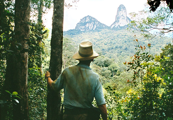
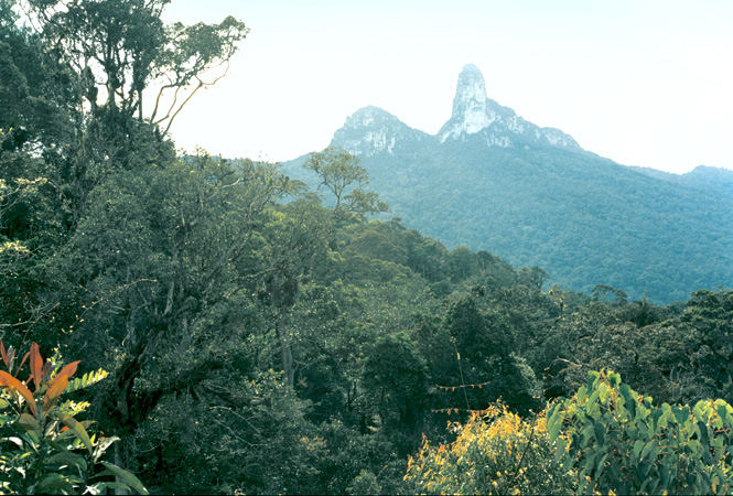
Above: The author viewing Batu Lawi from across the valley.
A remote mountain in Sarawak provides a unique perspective on the environmental challenges facing Malaysia’s largest state
By Jonny Beardsall
Explorer and Borneo scholar Tom Harrisson first visited the Kelabit Highlands of northeast Sarawak in 1932, as a young ornithologist on an Oxford University expedition. When he returned to Borneo during World War II as a major with Britain’s Special Operations Executive, his mission was to identify friendly tribes and to raise a native force to stop the occupying Japanese from making incursions inland.
In March 1945, Harrisson flew with a team of commandos in a Royal Australian Air Force bomber, hoping to parachute into Sarawak’s rugged interior. Marking their flight path was an extraordinary twin-peaked mountain called Batu Lawi—codenamed “Mount 200”—that Harrisson had seen from a distance on his original expedition. Day after day, low cloud obscured the highlands, but on the fifth sortie he dropped blindly into the mists and, miraculously, landed safely in a soggy paddy field in the Kelabit village of Bario. The aircraft failed to return to the Philippines and its fate remains unknown.
Harrisson was warmly received by the Kelabit people, who today number 3,000 in a string of 13 highland villages. Given that Sarawak was, until the Japanese invasion, ruled benevolently by the White Rajas (three generations of the English Brooke family), the tribesmen agreed to help Harrisson provide behind-the-lines intelligence. A guerrilla force was formed, a small irregular army of 1,000 blowgun-toting headhunters who eventually killed or captured 1,500 Japanese and successfully cut off enemy supply lines.
After the Japanese surrender, Harrisson took up residence in Kucing, where he became the curator of the Sarawak Museum. In 1946, he returned to Bario and reached the top of Batu Lawi’s smaller pinnacle, a journey recorded in the best-known of his 12 books, World Within: A Borneo Story. After a three-day trek and a strenuous final scramble, he tucked an inscribed wooden board into a niche near its summit in memory of the aircraft crew who never made it home.
I had a copy of Harrisson’s compelling World Within in my pocket when I first saw Batu Lawi in 1983, from the window of a small plane that was taking me to Bario. Batu Lawi back then was set deep in primeval jungle, closed off from the world in a sea of low white cloud. I was serving with the British Army’s 6th Gurkha Rifles regiment in Brunei and had taken a week’s leave to stay in Bario, one of the last places in Malaysian Borneo with no road access. I was a guest of Penghulu (chief) Ngimat Ayu, who told me stories of the sacred mountain with its two peaks, the male and female symbols of all the upland people. Since from Bario it would take two to three days of walking just to arrive at the foot of Batu Lawi, I asked if I could come back one day and try to climb it.
Two years later, I was halfway up the south face of the mountain’s upper peak—2,046 meters of knife-edged outcrop with sheer rock faces falling away on both sides—attempting the first recorded ascent. Drawing in the sodden rope, I heard the grunts of Mad Dog, my regimental climbing partner, as he joined me on a narrow ledge. He was shaking his head. After five days we were low on food and water, and the rock was perilously loose. Lichens and thorns strangled every handhold; the unremitting sun was roasting our backs.
Eventually we decided to try another route, from the north, which gave us a second chance at the summit. A huge two-day effort brought us to within 30 meters of the top. The most obvious route was blocked by an impenetrable swath of overhanging vegetation. I began a delicate move and reached for a hold that came away in my palm. I passed the piece of rock to Mad Dog, who managed a heroic grin. I moved another two meters and looked for a place to hammer in my last remaining piton. I was now on a slab on the exposed west wall. I banged in the peg and climbed farther. A few minutes later, just as the sun was setting, I wriggled onto the edge of the sloping summit. By 8 p.m., we lay exhausted on a patch of mountaintop jungle, where we slept, roped together, huddled on layers of dead vegetation. Thirteen days after leaving Bario, the peak was ours at last.
A quarter century later, I’ve returned to the Kelabit Highlands. I expect the landscape to have changed drastically since my last visit; Sarawak has reportedly logged 90 percent of its primary forest, even as far as the edges of this plateau. Seen from the air, what were once the most inaccessible parts of the forest are scarred by the red ocher smudges of logging roads. Clear-cutting on this scale poses a threat not only to the local wildlife (which includes such endangered species as orangutans, sun bears, and clouded leopards), but also to the traditional ways of the Kelabit people and, more particularly, the Penan, the nomadic hunter-gatherers who live in the forests around Batu Lawi.
On a positive note, a sizable chunk of the highlands—almost 60,000 hectares—became a national park in 2005, which should make it possible to protect the remainder of this unique pocket of montane forest. Known as Pulong Tau (“our forest” in the Kelabit language), the preserve includes the Tama Abu range and Mount Murud, Sarawak’s highest peak. Incredibly, it does not include Batu Lawi; the Kelabits are campaigning for its inclusion, but face stiff opposition from logging companies.
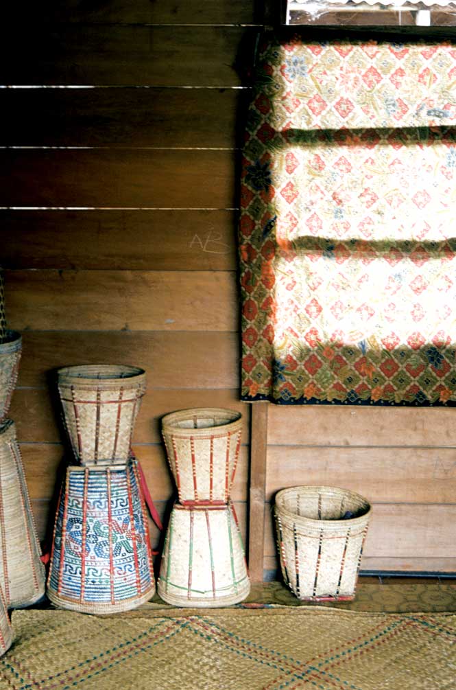
Bario itself hasn’t changed all that much. The old grass airstrip —now grazed by water buffalo—has been superceded by a concrete runway outside town, and there are more guesthouses than I remember; a growing number of eco-minded tourists are visiting the area for guided hikes between highland villages.
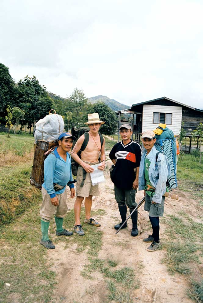
On this trip, I’ve set my sights on a less-ambitious scramble up Batu Lawi’s smaller peak, which won’t require ropes or climbing equipment. John Tarawe, the owner of my Bario guesthouse and a prominent member of the Kelabit community, has pioneered several tourism and development programs in the highlands. In no time, he’s recruited a guide, Johness, and two porters from the nearby longhouse settlement of Pa Ukat to join my excursion.
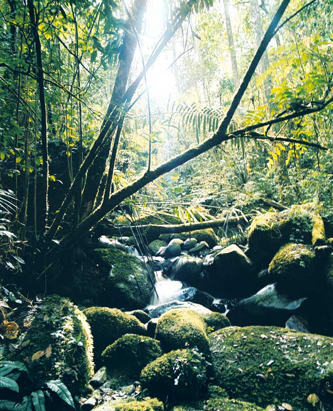
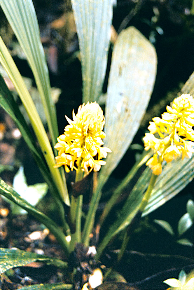
We head off early the next day. Even at a seemingly cool 1,000 meters, and despite the shade of the rain forest canopy, the freshness of dawn is soon eclipsed by a fierce heat. I am unused to the near-100 percent humidity and my pace is painfully slow. We slip and crawl up precipitous spur sides, with flesh-tearing thorns of the wait-a-while fern dragging at our sodden clothing, before making inevitable lunges down steep far sides. At noon we cross the Tama Abu ridge. The trees are stunted and the track garlanded with exquisite pitcher plants, orchids, and rhododendrons. Pausing in the summit gap, I scrape away some moss to reveal the spread-eagled figure of a man carved in the stone. Johness says this marks our route as an ancient Kelabit hunting trail.
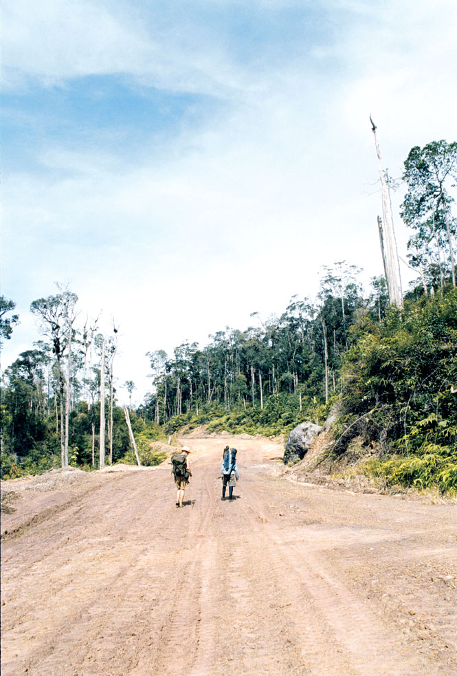
As we descend, the tree cover overhead breaks and we blink like moles emerging from their burrows, shielding our eyes from the sunlight. I’m shocked by what I see. The last time I was here, it seemed impossible that bulldozers and chainsaws would ever threaten this impenetrable landscape. But the loggers have pushed between Bario and Batu Lawi and advanced to the very edge of the national park. Our track opens onto a linear clearing that, a kilometer on, joins a well-maintained logging road. Secondary scrub grows in the scars left by heavy machinery, and a river crossing spanned by a heavy bridge is littered with rubbish and old oil drums. It’s a grim sight, as is the disused workers’ hut where we spend the night.
Next morning, we meet men at work on the road. Its steep sides are prone to landslides when it rains, which it does every day. No timber has yet been extracted, but the men say it soon will be. Farther on, we pick up the old trail again. From a gap afforded by a natural landslip, I watch a pair of helmeted hornbills playing in a treetop, and I glimpse Batu Lawi a couple of kilometers away, glistening white in the greenness.
Beyond the Tabun River, the final grubby, uphill scrabble to the foot of the peak crosses stream after stream and is just as I remember it. Closer to the mountain, the path grows steeper, the trees are spaced farther apart, and the jungle floor is scattered with chunks of exposed stone. Suddenly, at 1,700 meters, the scrub-covered base of a vast rock face looms up in front of us.
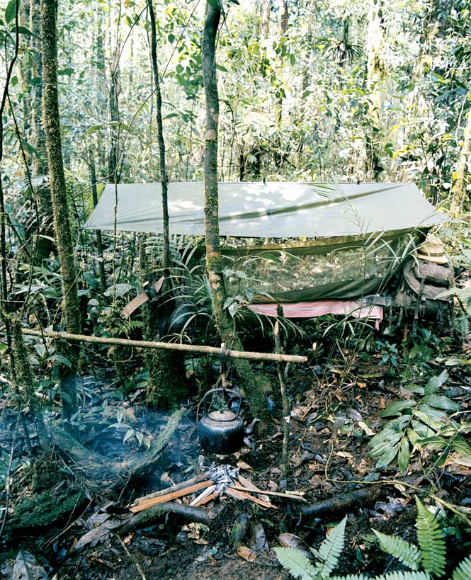
It takes half an hour to hike up to the bare “saddle” between the two pinnacles. A heavy rain is falling, and it has turned cold; mist and cloud obscure the view. I begin climbing the lower peak. It’s slippery, and the wind is gusting as I press on for the top.
Just below the summit a bronze plaque is bolted on a wall, a replica of the wooden one left by Harrisson in 1946 to commemorate his aircrew. We’re soon huddled under an umbrella—an essential item for the jungle traveler—on the squelchy, rhododendron-covered mountaintop, which is large enough to fit a couple of tents. On a bright day, I’d be able to see almost 160 kilometers to the far distant peaks of Kalulong and Dulit and, just 65 kilometers away, that of Mount Mulu. I’d also be able to see the devastation that Malaysia’s ruinous forest policy is creating in the near and middle distance. I’m relieved that the mist does not clear.
THE DETAILS:
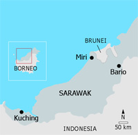
Kelabit Highlands
Getting There
Malaysia Airlines subsidiary MASwings (maswings.com.my) flies daily between Miri—the second-largest city in Sarawak— and Bario. Miri itself is served by regular Malaysia Airlines (malaysiaairlines.com) flights from Kuala Lumpur, by a Johor Bahru service operated by Air Asia (airasia.com), and by domestic flights from Kuching, the state capital.
When to Go
The Kelabit Highlands can be wet at any time of the year, though it’s best to avoid the October–February rainy season.
Tours
For information on guesthouses and guide services in the Kelabit Highlands, visit eBario.com, the community’s Internet portal. Alternatively, arrange a tailor-made excursion through Borneo Adventure (borneoadventure.com), a reliable tour operator with offices in Kuching, Miri, and Kota Kinabalu, Sabah.
Originally appeared in the June/July 2009 print issue of DestinAsian magazine (“Return to Batu Lawi”)